From Alpine Peaks to Southern Shores: Two Epic American Road Trips
The pine-scented air of the Eastern Sierra rolls through the open windows as the tires hum against State Route 158, while miles away on the Atlantic coast, salt spray mists the windshield just past Charleston’s cobblestone streets. Whether you’re chasing alpine solitude or lowcountry charm, the American road trip still holds that rare promise: the freedom to trade rigid itineraries for instinct. But a great drivecation isn’t just about mileage. It’s about knowing where to pull over, when to book ahead, and which stretches of highway actually reward the detour.
The Draw
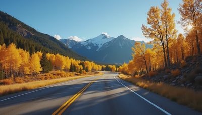
Most travelers default to Route 66 nostalgia, but the real magic lies in the routes that shift landscapes every few tankfuls of gas. The Eastern Sierra loop stitches together Lake Tahoe, Yosemite National Park, and Mammoth Lakes into a two-week mountain pilgrimage. It’s a landscape that demands you slow down, whether you’re ziplining through limestone at Moaning Caverns Adventure Park, standing beneath the hollowed trunk of the California Tunnel tree near Wowona Point, or watching rock climbers scale the 3,000-foot face of El Capitain. Alternatively, the coastal crawl strings Charleston’s antebellum history, the Sea Islands’ wildlife-rich shores, Tybee Island, and Destin into a cross-state shoreline run. Both itineraries reward drivers who treat their vehicle as a mobile basecamp rather than a mere transit tube.
What to Expect
Driving the Sierra means trading coastal humidity for thin, crisp air. You’ll cover 29.6 miles from North Lake Tahoe down to the southern valley, then tackle the 184-mile stretch to Yosemite. The road itself is the main attraction, particularly along the June Lake loop and through the pine-draped corridors of Inyo National Forest. Pack for four seasons: spring brings wildflower hikes and bike rides, summer opens lake beaches and watersports, fall paints the aspens gold, and winter turns Mammoth and North and South Lake Tahoe into powder destinations. The coastal route, by contrast, trades elevation for humidity. After 86.4 miles south from Charleston to the Sea Islands, you’ll find Harbor Island’s dolphin-watching waters and endless sandy stretches. The trade-off is real: summer brings sudden afternoon thunderstorms, and peak-season traffic can turn scenic coastal highways into slow-moving grids. Neither route is cheap if you wing it. Accommodation demand spikes around holidays and ski season, and last-minute motel hunting will drain your budget faster than a heavy foot on a mountain grade.
Insider Tips
Most travelers rush Yosemite’s main valley and miss the quiet pull-offs along State Route 158. Take the June Lake loop slowly; it’s a string of half a dozen alpine lakes that rarely see the crowds that flood Tunnel View. In the Sierra, book pet-friendly lodges in Mammoth Lakes or modern condos near Tahoe early—places with hot tubs and private parking fill months ahead of winter. On the coast, skip the main Sea Island thoroughfares and look for Harbor Island’s quieter access points where you can actually spot dolphins without fighting for a parking spot. Charleston’s French Quarter and Battery districts are best explored on foot before noon, when horse-drawn carriage tours clog the cobblestones. If you’re driving in summer, fill your tank in smaller towns rather than tourist hubs. And always verify your rental’s parking situation—many luxury villas include private driveways, but not all, and street parking in historic districts is a gamble.
Before You Go
When to go: Spring, summer, fall, or winter, depending on your priority. Spring and fall offer mild hiking and bike rides; summer opens lake beaches and watersports; winter brings skiing to Mammoth and North and South Lake Tahoe.
How long to spend: Two weeks is the sweet spot for either itinerary, giving you enough time to cover the mileage without rushing.
Getting there: Both routes are designed as point-to-point drives. The Sierra route begins at North Lake Tahoe and winds through Yosemite toward Mammoth Lakes. The coastal route starts in Charleston and heads south through the Sea Islands, Tybee Island, and Destin.
Budget & booking: Set a clear budget before you turn the key. Accommodation costs escalate quickly if you wait. Reserve your rental property in advance through Top Villas to secure luxury homes with private parking, pools, and pet-friendly options. Pre-booking eliminates last-minute motel hunting and keeps your daily costs predictable.
What to pack: Seasonal gear for rapid weather shifts, comfortable shoes for canyon and historic district walks, and a reliable navigation system. Cell service drops in stretches of Inyo National Forest, so offline maps are essential.